By Brujula Digital:
An environmental geomatics team establishes that 14 million hectares burned in Bolivia in 2024
The environmental geomatics team confirmed that 14,047,301 hectares burned, reaffirming Tierra’s statement that it was Bolivia’s greatest environmental disaster.
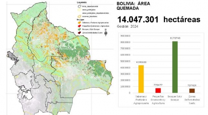
Data from the Environmental Geomatics Team. Photo: Sumando Voces
An environmental geomatics team, conducting a study using satellite monitoring with the Modis Terra sensor, convened by the newspaper El Deber, determined that in 2024, forest fires burned 14 million hectares in Bolivia, 8 million of which were forested areas.
Until now, the only data available were from the Fundación Tierra and the Government. Fundación Tierra had monitored the fires until the end of September, determining that 10 million hectares had burned by then, while the Government reported that 9.8 million hectares had burned by mid-October. However, the fires continued throughout that month.
The data published by El Deber, which Sumando Voces also accessed through a presentation, confirmed that 14,047,301 hectares burned, reaffirming Fundación Tierra’s statement that this was Bolivia’s greatest environmental disaster.
Santa Cruz was the most affected department, with 9,149,469 hectares burned, followed by Beni with 3,888,879 hectares. In La Paz, half a million hectares burned, and in Pando, 171,616 hectares were affected.
In the San Matías Integrated Management Natural Area (ANMI), 1.6 million hectares burned, accounting for more than half of its surface area. Additionally, 820,818 hectares burned in Monte Verde, another severely affected region.
Rafael Cabrera, an expert in Remote Sensing and Geographic Information Systems (GIS), noted that the increasing availability of satellite data has made it easier to observe the Earth’s surface at different spatial, temporal, and spectral resolutions. Using this data, the academic and scientific community, as well as the general public, can access information about burned areas with coarse resolution over long time series, which is crucial for evaluating fire impact, vegetation recovery, carbon emissions estimates, and more. This information should be useful for environmental management and planning, according to the El Deber report.
He added that this technology detects a large number of fires in Bolivia each year, but 2024 saw an alarming increase. “In June, July, and September, the fires broke records, according to an analysis of Modis data,” he explained.
Environmental geomatics is the use of geographic information systems (GIS) and other technologies to study and manage the environment.
Geomatics is a discipline that combines geosciences with information and communication technologies (ICT). Its goal is to capture, process, analyze, interpret, and disseminate geospatial information.
Por Brújula Digital:
Un equipo de geomática ambiental establece que en Bolivia se quemaron 14 millones de hectáreas en 2024
Equipo de geomática ambiental establecen que se quemaron 14.047.301 hectáreas, lo que ratifica lo dicho por Tierra, que fue el mayor desastre ambiental de Bolivia.
Datos de equipo geomática ambiental. Foto: Sumando Voces
Un equipo de geomática ambiental, que hizo un estudio a través del monitoreo satelital con el sensor Modis Terra, convocado por el diario El Deber, estableció que en 2024, los incendios forestales dejaron 14 millones de hectáreas quemadas, de las cuales, 8 millones tenían cobertura boscosa.
Los únicos datos que existían hasta la fecha, eran los de la Fundación Tierra y los del Gobierno. La Fundación Tierra había realizado un monitoreo hasta finales de septiembre, estableciendo que hasta entonces se habían quemado 10 millones de hectáreas, mientras que el Gobierno había informado que hasta la primera quincena de octubre se quemaron 9,8 millones de hectáreas. Sin embargo, los incendios continuaron durante todo ese mes.
Los datos publicados por El Deber, a los que también tuvo acceso Sumando Voces mediante una presentación, establecen que se quemaron 14.047.301 hectáreas, lo que ratifica lo dicho por Tierra, que fue el mayor desastre ambiental de Bolivia.
Santa Cruz fue el departamento más afectado, con un área quemada de 9.149.469 de hectáreas; seguido de Beni, con 3.888.879 de hectáreas. En La Paz se quemó medio millón de hectáreas y en Pando 171.616 hectáreas.
En el Área Natural de Manejo Integral (ANMI) San Matías se quemaron 1,6 millones de hectáreas, más de la mitad de su superficie. Y, según el levantamiento de datos, en Monte Verde se quemaron 820.818 hectáreas. Esa región fue otra de las áreas más afectadas.
Rafael Cabrera, experto en Remote Sensing y Sistemas de Información Geográfica (SIG), dijo que gracias a creciente disponibilidad de datos satelitales se ha facilitado la observación de la superficie terrestre en diferentes resoluciones espaciales, temporales y espectrales y que, utilizando estos datos, la comunidad universitaria y científica, y la ciudadanía en general, pueden informarse acerca de área quemada de resolución gruesa de series largas de tiempo, que son claves para la evaluación del impacto del incendio, de la recuperación de la vegetación, de la estimación de las emisiones de carbono, etc., que debería ser útil para la gestión y planificación ambiental, según el reporte de El Deber.
Agregó que con esta tecnología se detecta una gran cantidad de incendios en Bolivia cada año, pero que en 2024 hubo un aumento alarmante, “en junio, julio y septiembre el fuego batió récords, según un análisis de los datos de Modis”, explicó.
La geomática ambiental es el uso de sistemas de información geográfica (SIG) y otras tecnologías para estudiar y controlar el medio ambiente.
La geomática es una disciplina que combina las geociencias con las tecnologías de la información y la comunicación (TIC). Su objetivo es capturar, procesar, analizar, interpretar y difundir información geoespacial.
