ANF, Los Tiempos:
FAN quantifies the area burned by fires in 8 months at 1.5 million hectares
The Friends of Nature Foundation (FAN) quantified in more than 1.5 million hectares the areas burned by the fires in the nine regions of the country, from January to August of this year.
To perform the quantification, Sentinel-2 images with a resolution of 20m were used and more than 1,233 images were processed on the Google Earth Engine platform.
“From this methodology, more than 1.5 million accumulated burned hectares were detected in the last eight months of the year 2021 at the national level, corresponding to the period from January 1 to August 31,” says the institution.
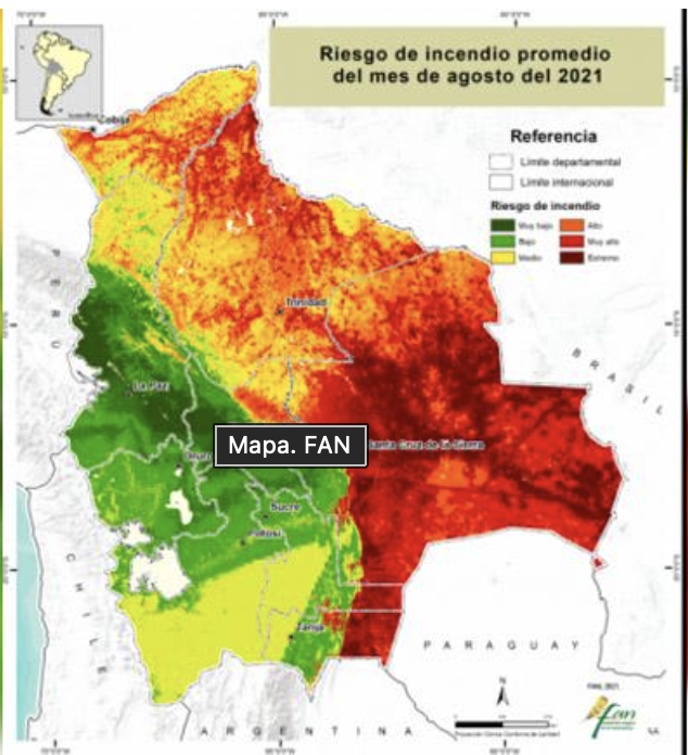
The report reveals that the departments of Santa Cruz and Beni concentrate 92% of burned areas: 46.2% are concentrated in the department of Beni and 46.0% in the department of Santa Cruz.
Until the end of August, the burned area in the department of Santa Cruz amounts to 705 thousand hectares, with a significant increase of 88% compared to July. While in the department of Beni the burned area amounts to 703 thousand hectares, a moderate increase of 38% compared to the same month.
The forest area affected by forest fires covers more than 189 thousand hectares and represents 12% of the total burned areas nationwide. The areas burned in non-wooded lands (grasslands, herblands, scrublands) add up to 1.3 million hectares, which represents 82% of the total and the remaining 6% (92 thousand hectares) was detected in agricultural areas.
The municipalities of San Matías, Charagua, San José de Chiquitos and Roboré in the department of Santa Cruz; Exaltación, San Ramón, Yacuma and Reyes in the department of Beni; and Ixiamas in the department of La Paz are the 10 most affected municipalities nationwide, concentrating 69% of the burned areas until August.
43% (658 thousand hectares) of the total burned area is concentrated in national and sub-national protected areas. 22% (337 thousand hectares) are concentrated in 20 protected areas.
21% (321 thousand hectares) of the burned areas at the national level are concentrated in 21 sub-national protected areas.
19% (290 thousand hectares) of the burned areas until August are concentrated in 22 indigenous territories.
During the month of August, an increase of 60% in the burned area was recorded compared to July, associated with the extreme risk conditions reported in the regions most affected by forest fires due to climatic conditions and the decrease in humidity of the vegetation.
FAN cuantifica en 1,5 millones de hectáreas la superficie quemada por incendios en 8 meses
La Fundación Amigos de la Naturaleza (FAN) cuantificó en más de 1,5 millones de hectáreas las superficies quemadas por los incendios en las nueve regiones del país, desde enero hasta agosto de la presente Gestión.
Para realizar la cuantificación se utilizó imágenes Sentinel-2 con una resolución de 20m y se procesaron más de 1.233 imágenes en la plataforma de Google Earth Engine.
“A partir de esta metodología se detectaron más de 1,5 millones de hectáreas quemadas acumuladas en los últimos ocho meses del año 2021 a nivel nacional, correspondientes al periodo desde el 1º de enero al 31 de agosto”, señala la institución.
El informe revela que los departamentos de Santa Cruz y Beni concentran el 92% de áreas quemadas: el 46,2% se concentra en el departamento de Beni y el 46,0% en el departamento de Santa Cruz.
Hasta finales de agosto, la superficie quemada en el departamento de Santa Cruz asciende a 705 mil hectáreas, con un incremento importante de 88% con respecto al mes de julio. Mientras que en el departamento del Beni la superficie quemada asciende a 703 mil hectáreas, un incremento moderado de 38% con relación al mismo mes.
La superficie de los bosques afectados por los incendios forestales abarca más de 189 mil hectáreas y representa el 12% del total de áreas quemadas a nivel nacional. Las áreas quemadas en tierras no boscosas (pastizales, herbazales, matorrales) suman 1,3 millones de hectáreas, lo que representa el 82% del total y el restante 6% (92 mil hectáreas) se detectó en áreas agropecuarias.
Los municipios de San Matías, Charagua, San José de Chiquitos y Roboré en el departamento de Santa Cruz; Exaltación, San Ramón, Yacuma y Reyes en el departamento del Beni; e Ixiamas en el departamento de La Paz son los 10 municipios más afectados a nivel nacional, y concentra el 69% de las áreas quemadas hasta agosto.
El 43% (658 mil hectáreas) de la superficie total quemada se concentra en áreas protegidas nacionales y subnacionales. El 22% (337 mil hectáreas) se concentra en 20 áreas protegidas.
El 21% (321 mil hectáreas) de las áreas quemadas a nivel nacional se concentra en 21 áreas protegidas subnacionales.
El 19% (290 mil hectáreas) de las áreas quemadas hasta agosto se concentra en 22 territorios indígenas.
Durante el mes de agosto se registró un incremento de 60% de la superficie quemada respecto a julio, asociado a las condiciones de riesgo extremo reportado en las regiones más afectados por los incendios forestales debido a las condiciones climáticas y la disminución de humedad de la vegetación.
