By Carlos Quisbert, Vision 360:
They foresee that the figures will increase
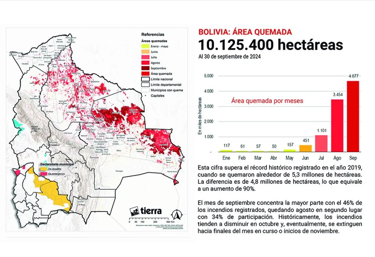
Data from Fundación Tierra reveals that the 10,125,400 hectares represent a 90% increase in the area of land burned compared to 2019.
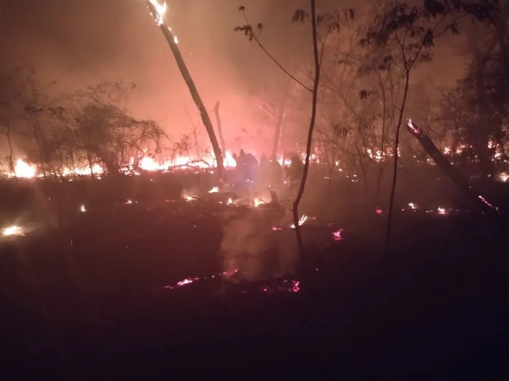
One of the forest fires affecting Santa Cruz. Photo: GADSC
10% of Bolivia has already burned, and the “environmental tragedy” could worsen this month, according to data from Fundación Tierra regarding the number of hectares affected by forest fires. The “independent” information reveals that 10,125,400 hectares have been consumed by fire, based on satellite data from various international institutions.
“This is a dramatic situation, an environmental tragedy (…) We’re talking about a scenario where nearly 10% of the country has burned,” said Fundación Tierra researcher Gonzalo Colque.
The conclusions of the preliminary report, with independent data, indicate that as of September 30, the forest fires surpass “all historical records in terms of burned area and heat points.”
In this context, it is mentioned that the forest fires at the national level have burned 10,125,400 hectares, a 90% increase compared to 2019, when 5.3 million hectares were affected, considered one of the worst precedents.
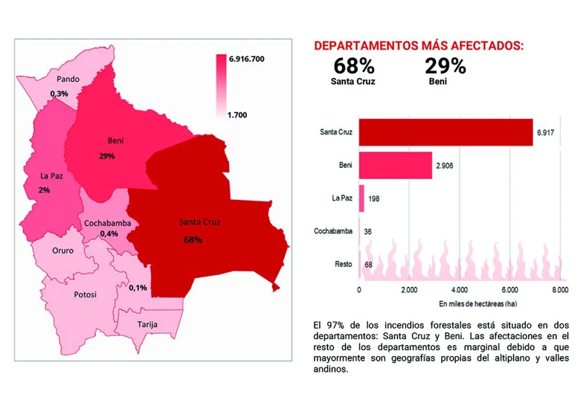
The data from Fundación Tierra highlight that, in the department of Santa Cruz, the affected area reached 6,906,700 hectares by the end of September, representing a 103% increase compared to 2019, when 3.4 million hectares were recorded.
The institution emphasized that the fire season begins in June and extends until October each year, “so it is expected that the final data for this year will continue to rise in the coming days and weeks. 58% of the burned area consists of forests, while the remaining 42% includes non-forest vegetation, such as pastures, low-vegetation plains, savannas, or flood-prone areas,” the report states.
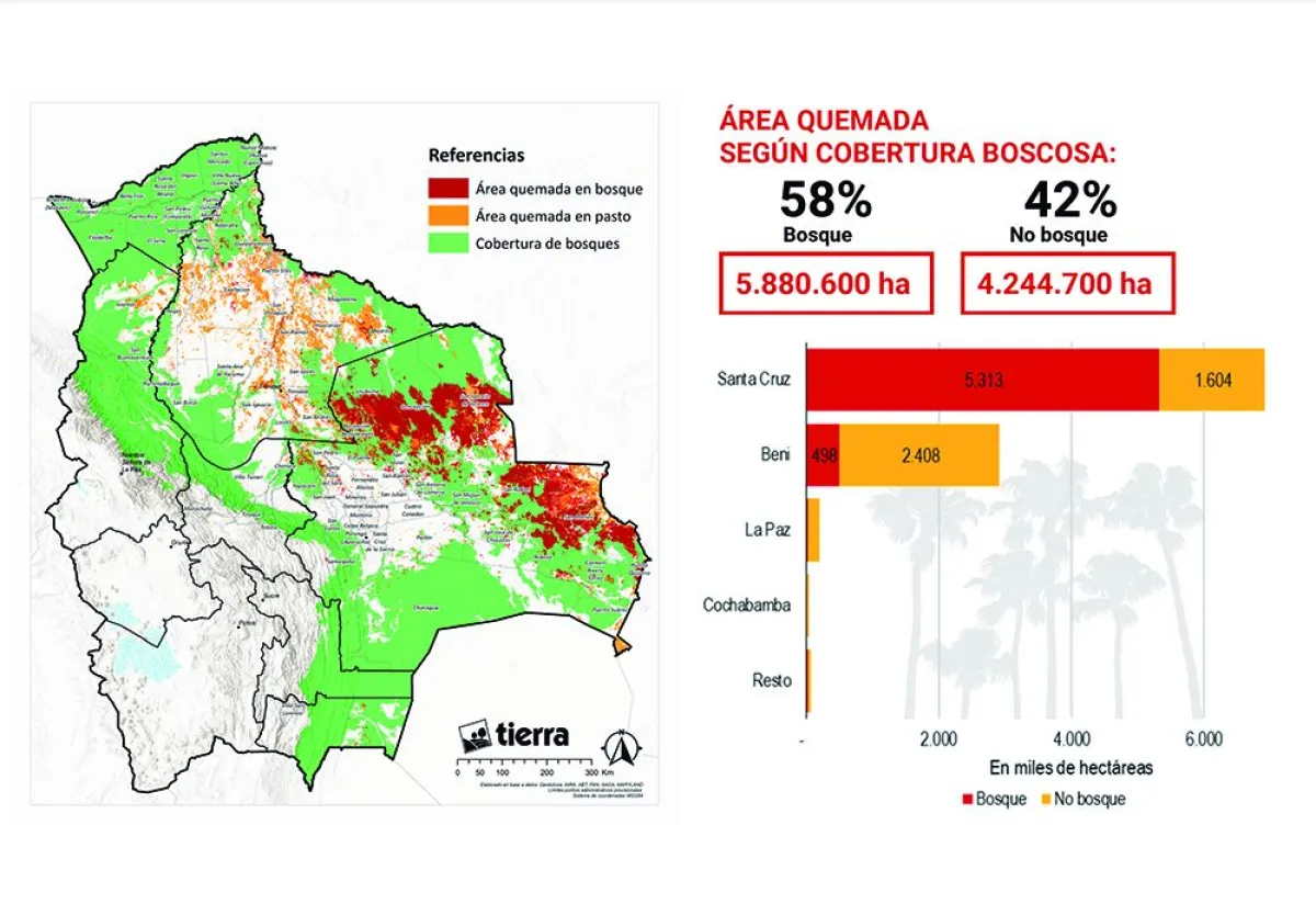
The most affected department is Santa Cruz, with 6,916,700 hectares burned, of which 77% is forest and the remaining 23% is non-forest. The three most affected municipalities in Santa Cruz are San Matías, San Ignacio de Velasco, and Concepción, which account for 66% of the registered fires.
Additionally, the report reveals that 50% of the burned area in Santa Cruz occurred on private agricultural land, 28% in Indigenous Community Territories (TCO), and 22% in Protected Areas. Other types of agricultural properties affected by the fires include those owned by companies and lands classified as state property.
In one section, Fundación Tierra emphasizes the importance of differentiating between agricultural properties “responsible for the fire” and those that are “victims of the uncontrolled spread of the fire.” Separating the culprits from the victims is essential for in-depth analysis, according to the report, with a more detailed account to follow.
“Preliminarily, we conclude that the two main types of agricultural property involved are: large cattle ranches with deforestation authorizations from the ABT and communities settled by the INRA on state land. A significant portion of the fires originated in areas cleared for large-scale monocultures,” the document states.
Por Carlos Quisbert, Vision 360:
Prevén que las cifras aumenten
Los datos de Fundación Tierra revelan que las 10.125.400 hectáreas representan un incremento del 90% de la extensión de tierras que se quemaron en 2019.
Uno de los incendios forestales que afectan a Santa Cruz. Foto: GADSC
El 10% de Bolivia ya se incendió y la “tragedia ambiental” podría incrementarse este mes, según los datos de la Fundación Tierra, en relación a la cantidad de hectáreas afectadas por los incendios forestales. La información “independiente” revela que el fuego arrasó con 10.125.400 hectáreas y toma en cuenta datos satelitales de diferentes instituciones internacionales.
“Esta es una situación dramática, es una tragedia ambiental (…) Estamos hablando de un escenario en el que prácticamente el 10% del país se ha quemado”, afirmó el investigador de Fundación Tierra, Gonzalo Colque.
Las conclusiones del informe preliminar, con datos independientes, señalan que los incendios forestales, hasta el 30 de septiembre, superan “en área quemada y focos de calor de todos los registros históricos”.
En ese contexto se menciona que los incendios forestales, a nivel nacional, alcanzaron las 10.125.400 hectáreas quemadas, lo que significa un incremento del 90%, respecto a 2019, cuando se contabilizaron 5,3 millones hectáreas, considerado uno de los peores antecedentes.
Los datos de Fundación Tierra remarcan que, en el departamento de Santa Cruz, el área afectada alcanzó 6.906.700 hectáreas, hasta fines de septiembre, por lo que el incremento llega al 103% con respecto a los datos del 2019, cuando se registró 3,4 hectáreas.
La institución remarcó que la temporada de incendios inicia en junio y se extiende hasta octubre de cada año, “por lo que es previsible que los datos finales de la presente gestión sigan aumentando en los próximos días y semanas. El 58% del área quemada son bosques y el restante 42% son tierras de vegetación no boscosa como ser pasturas, llanuras de vegetación baja, sabanas o zonas inundadizas”, menciona el informe.
El departamento más afectado es Santa Cruz, con 6.916.700 hectáreas quemadas, de las cuales el 77% es bosque y el restante 23% no bosque. Los tres municipios cruceños más afectados son San Matías, San Ignacio de Velasco y Concepción, mismos que concentran el 66% de los incendios registrados.
Asimismo, el informe revela que el 50% del área quemada en Santa Cruz se produjo, el 28% en Territorios Comunitarios de Origen (TCO) y 22% en Áreas Protegidas. Otros tipos de propiedad agraria en los que el fuego se propagó corresponden a las que están en poder de empresas y las que son clasificadas como tierras fiscales.
En uno de los puntos, la Fundación Tierra señaló que es importante diferenciar entre aquellas propiedades agrarias “causantes del fuego” y las propiedades agrarias “víctimas de la propagación descontrolada del fuego. Separar a los culpables y víctimas es fundamental para al análisis en profundidad”, señala el informe y anunciaron que más adelante se dará un reporte más detallado.
“Preliminarmente, concluimos que los principales tipos de propiedad agraria implicados son dos: las grandes propiedades ganaderas con autorizaciones de desmontes de la ABT y las comunidades asentadas por el INRA en tierras fiscales. Gran parte de los incendios tiene su origen en las áreas desmontadas para monocultivos a gran escala”, señala el documento.
