By Javier Gómez, Rimay Pampa:
After three weeks of social and political conflict, and an analysis of the areas where each roadblock was established, it becomes clear that behind the social demands lies an overlap of legal, informal, and illegal economies competing for control of Bolivian territory.
The road accessibility map released by the ABC during the recent conflicts showed dozens of red points stretching across the country. At first glance, they appear to be simple social roadblocks. But a closer look reveals something much deeper: a new cartography of power in Bolivia.
The critical points do not appear at random. Many coincide with historic trade corridors, extractive zones, territories dominated by informal economies, and routes where drug trafficking, smuggling, gold mining, and local corporate structures converge. Bolivia’s conflict long ago ceased to be solely an ideological dispute between left and right, or between social movements and the state. Today, it also reflects a territorial competition among multiple economies seeking to control routes, revenues, and political leverage.
The old national-popular narrative is no longer sufficient to explain this reality. For decades, Bolivia interpreted its crises through more clearly defined social actors: workers, peasants, and Indigenous peoples confronting bourgeoisies and elites that historically controlled the state apparatus.
But the country has changed profoundly. The weakening of formal wage labor, the expansion of informal economies, the rise of extractivism, and the growing penetration of illegal capital have transformed the social and territorial map. In this new scenario, a majority of wage earners and semi-wage informal workers coexist with a diverse array of small and large property owners who continue to organize themselves as workers and/or peasants.
Likewise, legal, informal, and illegal economies are no longer separate; rather, they overlap and feed off one another. Territories—departments, cities, and communities—are increasingly defining their own socioeconomic profiles, their key actors, and the power to impose their interests.
Chapare: Territorial Control and a Surplus Economy
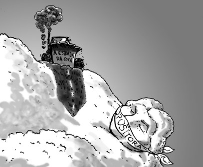
Chapare has a solid union structure, a territory with a strong political identity, and a complex agricultural economy where small producers, transport operators, traders, and surplus coca circuits coexist. Its capacity for roadblocks and mobilization stems not only from ideology or union organization but also from territorial and logistical control built over decades.
There, the state does not exercise absolute authority; it constantly negotiates with consolidated local powers.
Northern Potosí: From Siglo XX to “Little Mexico”
The situation in Llallagua, Siglo XX, and areas linked to ayllus such as Qaqachacas and Laymes carries enormous symbolic weight. These were historic territories of mining unionism, labor struggles, and Bolivia’s revolutionary memory. Today, they are increasingly associated in the national imagination with violence, illegal economies, and fragmented territorial control.
Recent official and media references to “Little Mexico” marked a turning point. Reports concerning marijuana plantations, cocaine laboratories, illegal vehicles, and improvised armed groups began circulating around Llallagua and nearby areas.
Beyond possible media exaggerations, what is significant is that the state itself has begun publicly acknowledging the convergence of strong community structures, illegal economies, autonomous territorial control, and local coercive capacity.
The transformation is profound. Siglo XX symbolized the centrality of organized mining labor. “Little Mexico” symbolizes the territorial fragmentation that followed the collapse of formal employment after the relocation process and state abandonment.
The ayllus of northern Potosí possess a long tradition of self-defense and territorial organization. But in the absence of a unifying national economic horizon, some of these structures have become intertwined with highly profitable and weakly regulated new economies. The result is an explosive combination of communal memory, economic crisis, and transnational illegal networks.
Charazani and Northern La Paz: The Gold and Cocaine Corridor
The Charazani region and northern La Paz reveal another dimension of this invisible geography. There, gold mining, informal trade, cross-border movement, and routes associated with illegal gold, mercury, and cocaine converge.
Municipalities connected to Guanay, Tipuani, Teoponte, and Apolo form part of Amazonian corridors marked by a historic absence of state presence. Rising international gold prices have multiplied informal extractive economies and strengthened mining cooperatives with enormous political influence.
In these territories, members of the same family may simultaneously participate in agriculture, mining, transportation, informal commerce, and illegal circuits. The boundary between popular economy and illicit accumulation becomes increasingly blurred.
Patacamaya and Challapata: The Power of the Highways
Patacamaya and Challapata perhaps represent the most strategic dimension of the problem because of their control over the country’s logistics. Patacamaya connects La Paz with Oruro, Chile, and the country’s central axis, while Challapata links corridors leading toward Potosí and Pacific border crossings.
Both areas frequently appear in reports concerning smuggling, undocumented vehicles, cocaine trafficking, and irregular fuel distribution.
But the key issue is not merely illegality. What matters is that unionized transportation, informal commerce, and smuggling converge there alongside clandestine networks.
When Patacamaya or Challapata are blocked, Bolivia is literally territorially fractured. The highway ceases to be a simple transit space and becomes the principal instrument of political and economic power. Controlling a corridor means controlling supplies, exports, imports, fuel distribution, and national pressure on the government.
This is why the current roadblocks have such a devastating impact: they express not only social demands but also disputes over territorial control and the preservation of economic rents.
El Alto: The Capital of the Informal Economy
If Chapare represents coca-based territorial power and northern Potosí reflects post-relocation fragmentation, El Alto represents the urban consolidation of Bolivia’s diverse economic forms.
The city can no longer be understood solely as a symbol of popular rebellion or a historic stronghold of Indigenous and neighborhood mobilizations. It remains all of that, but it has also become one of the largest informal logistical and commercial centers in South America.
In El Alto converge commerce, smuggling, unionized transportation, giant marketplaces with regional merchandise flows, informal financial networks, and a growing parallel dollarized economy.
The 16 de Julio Fair symbolizes this transformation. What began as a popular market evolved into a massive economic platform where small merchants, medium-sized importers, smuggled technology, auto parts, Chinese goods, undocumented vehicles, and commercial circuits linking Bolivia to Chilean ports, Peru, Paraguay, and Brazil coexist. The city thus functions as a true informal “dry port” for the country.
That is why its political role is so decisive. The city possesses an enormous capacity to paralyze Bolivia, controls access to La Paz, influences supply chains, dominates logistical routes, and concentrates powerful trade and transportation organizations with significant mobilization capacity.
Unlike the old mining unionism, organized around wage labor and national ideological projects, many of El Alto’s newer organizations are structured around territorial corporate economies with substantial internal social differentiation, making the relationship between protest and economic interests far more complex.
In El Alto, mobilization does not express only political demands. It also protects entire economic circuits threatened by state controls, dollar shortages, import restrictions, or fuel crises. The city has thus become the space where the central contradictions of Bolivian society converge, a key location in the cartography of Bolivian power. It is no longer only the rebellious city of 2003. It is also one of the country’s principal centers of informal economic accumulation and territorial and political pressure.
The Exhaustion of the Model
During the cycle of high international commodity prices, the Bolivian state managed to partially administer these tensions through income redistribution, subsidies, and expanded public spending. Abundance and permissiveness allowed the growth and coexistence of multiple parallel economies without directly confronting them.
But economic slowdown, foreign currency shortages, political crisis, and institutional weakening have reduced the state’s capacity to arbitrate. The result is increasing fragmentation of territorial power.
Bolivia is slowly entering a stage in which different actors no longer seek only political representation, but also dominance over logistical corridors, regional economies, and strategic territories.
This is perhaps the most troubling aspect of the current situation: the state retains formal legitimacy, but is progressively losing its real monopoly over routes, economies, and territories.
Javier Gómez is an economist.
Por Javier Gómez, Rimay Pampa:
Después de tres semanas de conflictos sociales y políticos, y analizando las zonas de cada punto de bloqueo, se revela que detrás de las demandas sociales hay una superposición de economías legales, informales e ilegales que disputan el control del territorio boliviano.
El mapa de transitabilidad de la ABC difundido durante los recientes conflictos muestra decenas de puntos rojos atravesando el país. A primera vista parecen simples bloqueos sociales. Pero observados con detenimiento pueden revelar algo mucho más profundo: una nueva cartografía del poder en Bolivia.
Los puntos críticos no aparecen al azar. Muchos coinciden con corredores históricos de circulación de mercancías, zonas extractivas, territorios de economías informales y rutas donde confluyen narcotráfico, contrabando, minería aurífera y estructuras corporativas locales. El conflicto boliviano dejó hace tiempo de ser únicamente una disputa ideológica entre izquierda y derecha o entre movimientos sociales y Estado. Hoy expresa también una competencia territorial entre múltiples economías que buscan controlar rutas, rentas y capacidad de presión política.
La vieja narrativa de lo nacional-popular resulta insuficiente para explicar esta realidad. Durante décadas Bolivia interpretó sus crisis desde sujetos sociales más definidos, obreros, campesinos e indígenas contra burguesías y élites que controlaban históricamente el aparato estatal.
Pero el país cambió profundamente. El debilitamiento del trabajo asalariado formal, la expansión de economías informales, el auge del extractivismo y la creciente penetración de capitales ilegales transformaron el mapa social y territorial. En ese nuevo escenario, conviven una mayoría de trabajadores asalariados y semiasalariados informales con una diversidad de pequeños y grandes propietarios que siguen agremiándose como trabajadores y/o campesinos.
Asimismo, las economías legales, informales e ilegales dejaron de estar separadas, más bien se superponen y se retroalimentan y los territorios (departamentos, ciudades y comunidades) van definiendo su perfil socioeconómico, sus protagonistas y el poder para imponer sus intereses.
El Chapare: control territorial y economía excedentaria
El Chapare tiene una estructura sindical sólida, un territorio de fuerte identidad política y una economía agrícola compleja donde conviven pequeños productores, transportistas, comerciantes y circuitos excedentarios de coca. La capacidad de bloqueo y movilización no surge únicamente de la ideología o la organización sindical, sino del control territorial y logístico construido durante décadas.
Allí, el Estado no ejerce autoridad absoluta: negocia permanentemente con poderes locales consolidados.
Norte de Potosí: de Siglo XX a “México Chico”
La situación de Llallagua, Siglo XX y las zonas vinculadas a ayllus como Qaqachacas y Laymes tiene una enorme carga simbólica. Fueron territorios históricos del sindicalismo minero, de las luchas obreras y de la memoria revolucionaria boliviana. Hoy aparecen crecientemente asociados en el imaginario nacional a violencia, economías ilegales y control territorial fragmentado.
Las recientes referencias oficiales y mediáticas a “México Chico” marcaron un punto de inflexión. Denuncias sobre viveros de marihuana, laboratorios de cocaína, vehículos ilegales y grupos armados improvisados comenzaron a circular alrededor de Llallagua y zonas cercanas.
Más allá de posibles exageraciones mediáticas, lo significativo es que el propio Estado empezó a reconocer públicamente confluencia de estructuras comunitarias fuertes, economías ilegales, control territorial autónomo y capacidad coercitiva local.
La transformación es profunda. Siglo XX simbolizaba la centralidad del trabajo minero organizado. “México Chico” simboliza la fragmentación territorial posterior al colapso del empleo formal desde la relocalización y al abandono estatal.
Los ayllus del norte de Potosí poseen una larga tradición de autodefensa y organización territorial. Pero en ausencia de un horizonte económico nacional integrador, parte de esas estructuras quedó atravesada por nuevas economías altamente rentables y escasamente reguladas. El resultado es una combinación explosiva entre memoria comunitaria, crisis económica y circuitos ilegales transnacionales.
Charazani y el norte paceño: el corredor del oro y la cocaína
La región de Charazani y el norte de La Paz revela otra dimensión de esta geografía invisible. Allí convergen minería aurífera, comercio informal, circulación transfronteriza y rutas asociadas al oro ilegal, mercurio y cocaína.
Municipios conectados con Guanay, Tipuani, Teoponte o Apolo forman parte de corredores amazónicos con ausencia histórica del Estado. La expansión del precio internacional del oro multiplicó las economías extractivas informales y fortaleció cooperativas mineras con enorme capacidad política.
En estos territorios los componentes de una misma familia pueden participar simultáneamente en agricultura, minería, transporte, comercio informal y circuitos ilegales. La frontera entre economía popular y acumulación ilícita se vuelve cada vez más difusa.
Patacamaya y Challapata: el poder de las carreteras
Patacamaya y Challapata representan quizá la dimensión más estratégica del problema por el control logístico del país. Patacamaya conecta La Paz con Oruro, Chile y el eje central, y Challapata articula corredores hacia Potosí y las fronteras del Pacífico.
Ambas zonas aparecen recurrentemente en noticias sobre contrabando, vehículos indocumentados, tráfico de cocaína y circulación irregular de combustibles.
Pero lo central no es únicamente la ilegalidad. Lo central es que allí confluyen el transporte sindicalizado, el comercio informal y el contrabando, con redes clandestinas.
Cuando Patacamaya o Challapata se bloquean, Bolivia literalmente se fractura territorialmente. La carretera deja de ser un simple espacio de tránsito y se convierte en el principal instrumento de poder político y económico. Controlar un corredor significa controlar abastecimiento, exportaciones, importaciones, combustibles y presión nacional sobre el gobierno.
Por eso los actuales bloqueos, tienen un impacto tan devastador, no solo expresan demandas sociales, sino disputas por control territorial y preservación de rentas económicas.
El Alto: la capital de la economía informal
Si el Chapare expresa el poder territorial cocalero y el norte de Potosí la fragmentación postrelocalizacion, El Alto representa la consolidación urbana de las diversas formas de economía en Bolivia.
La ciudad ya no puede entenderse únicamente como símbolo de rebelión popular o bastión histórico de las movilizaciones indígenas y vecinales. Sigue siendo todo eso, pero además, en uno de los mayores centros logísticos y comerciales informales de América del Sur.
En El Alto convergen el comercio, el contrabando, el transporte sindicalizado, las ferias gigantescas con la circulación regional de mercancías y redes financieras informales, con una creciente economía dolarizada paralela.
La Feria 16 de Julio simboliza esa mutación. Lo que comenzó como mercado popular terminó convirtiéndose en una gigantesca plataforma económica donde conviven pequeños comerciantes, importadores medianos, tecnología de contrabando, autopartes, mercancías chinas, vehículos indocumentados y circuitos comerciales que conectan Bolivia con puertos chilenos, con Perú, Paraguay y Brasil. La ciudad funciona así como un verdadero “puerto seco” informal del país.
Por eso su papel político es tan decisivo. La ciudad posee enorme capacidad de paralizar Bolivia, controla accesos a La Paz, influye sobre el abastecimiento, domina rutas logísticas y concentra organizaciones gremiales y de transporte con gran capacidad de movilización.
A diferencia del viejo sindicalismo minero, articulado alrededor del trabajo asalariado y proyectos ideológicos nacionales, gran parte de las nuevas organizaciones alteñas se estructuran alrededor de economías corporativas territoriales con alta diferenciación social en su interior, haciendo mucho más compleja la interpretación entre protesta y economía.
En El Alto la movilización no expresa únicamente demandas políticas. También protege circuitos económicos enteros amenazados por controles estatales, escasez de dólares, restricciones a importaciones o crisis de combustibles. Así la ciudad se convirtió en el espacio donde confluyen las contradicciones centrales de la sociedad boliviana, en un lugar clave de la cartografía del poder boliviano. Ya no es solo la ciudad rebelde de 2003. Es también uno de los principales centros de acumulación económica informal y de presión territorial y política del país.
El agotamiento del modelo
Durante el ciclo de altos precios internacionales, el Estado boliviano logró administrar parcialmente estas tensiones mediante redistribución de renta, subsidios y expansión del gasto público. La abundancia y la permisividad, permitió el crecimiento y la coexistencia con múltiples economías paralelas sin confrontarlas directamente.
Pero la desaceleración económica, la escasez de divisas, la crisis política y el debilitamiento institucional redujeron la capacidad estatal de arbitraje. El resultado es una fragmentación creciente del poder territorial.
Bolivia ingresa lentamente en una etapa donde distintos actores ya no buscan únicamente representación política, sino dominio sobre corredores logísticos, economías regionales y territorios estratégicos.
Ese es quizá el dato más inquietante de la coyuntura actual: el Estado conserva legitimidad formal, pero pierde progresivamente el monopolio real sobre las rutas, las economías y los territorios.
Javier Gómez es economista
https://rimaypampa.org/opinion/javier-gomez-la-geografia-invisible-de-los-bloqueos/


Leave a Reply