By Vision 360:
Interactive map: this is what the devastation caused by alluvial mining on the Madre de Dios River looks like
Alluvial mining in Madre de Dios not only affects the environment, but also violates fundamental rights of the Indigenous nations that inhabit this part of the country, rich in biodiversity.
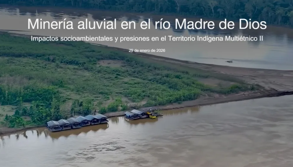
Cover of the interactive navigation map.
An innovative interactive map, developed by the Center for Legal Studies and Social Research (CEJIS), shows how alluvial gold mining impacts the Madre de Dios River, one of the main bodies of water in the Bolivian Amazon and a pillar of life for several Indigenous nations within the Multiethnic Indigenous Territory II (TIM II).
Alluvial gold mining—carried out by barges and dredges that scrape the riverbed and banks—alters the landscape, contaminates the waters, erodes biodiversity, and exposes the Tacana, Ese Ejja, and Kabineño communities to serious environmental and health risks. In this sense, the interactive map published by CEJIS makes it possible to fully understand the scale of these impacts.
What information can be found?
This digital tool allows users to visually and in detail explore the points where gold-mining barges are concentrated, the areas where mining operates inside or outside legally authorized zones, and how these activities overlap with community territories and the waterways that sustain the life and cultural practices of Indigenous peoples.
The interactive map shows the following information in a detailed, comparative, and contextualized way:
- Geospatial reference: it precisely reveals where extractions are taking place and how close they are to communities and environmentally sensitive areas.
- Contextualized data: it includes information from a diagnosis prepared by CEJIS together with Indigenous authorities and environmental monitors, detailing the presence of barges, extractive practices, and impacts on Indigenous people’s lives, health, territory, and collective rights.
- Comparative data: the information makes it possible to observe the expansion of illegal mining activity between 2021 and 2025.
Alluvial mining in Madre de Dios not only affects the environment, but also violates the fundamental rights of the Indigenous nations that inhabit this biodiverse area of the country. Although it is regulated by Bolivian legislation, a large part of the barges operate outside authorized areas, intensifying contamination by mercury and other toxic compounds, as well as the degradation of soils and waterways.
To view and navigate the interactive map, enter this link.
Por Vision 360:
Mapa interactivo: así se ve la devastación que causa la minería aluvial en el río Madre de Dios
La minería aluvial en Madre de Dios no solo afecta el medio ambiente, sino que vulnera derechos fundamentales, de las naciones indígenas que habitan esa zona el país, rica en biodiversidad.
Portada del mapa de navegación interactiva.
Un innovador mapa interactivo, desarrollado por el Centro de Estudios Jurídicos e Investigación Social (CEJIS), evidencia cómo la minería aurífera aluvial impacta al río Madre de Dios, uno de los principales cuerpos de agua de la Amazonía boliviana y pilar de la vida de varias naciones indígenas dentro del Territorio Indígena Multiétnico II (TIM II).
La minería aluvial de oro —activada por balsas y dragas que raspan el lecho y las riberas del río— altera el paisaje, contamina las aguas, erosiona su biodiversidad y expone a las comunidades Tacana, Ese Ejja y Kabineño a riesgos ambientales y sanitarios graves. En ese sentido, el mapa interactivo publicado por CEJIS permite comprender integralmente la dimensión de estos impactos.
¿Qué información se puede hallar?
Esta herramienta digital permite explorar de forma visual y detallada los puntos donde se concentran balsas auríferas, las zonas donde la minería opera dentro o fuera de áreas legalmente autorizadas, y cómo estas actividades se superponen con los territorios comunitarios y los cursos de agua que sustentan la vida y las prácticas culturales de los pueblos indígenas.
El mapa interactivo muestra la siguiente información de manera detallada, comparativa y contextualizada:
- Referencia geoespacial: revela con precisión dónde se están realizando las extracciones y su cercanía a comunidades y zonas ambientalmente sensibles.
- Datos contextualizados: incluye información de un diagnóstico elaborado por CEJIS con autoridades indígenas y monitores ambientales, que detalla la presencia de balsas, las prácticas extractivas y los impactos en la vida, la salud, el territorio y los derechos colectivos de los indígenas.
- Data comparada: la información permite observar la expansión de la actividad minera ilegal entre 2021 y 2025.
La minería aluvial en Madre de Dios no solo afecta el medio ambiente, sino que vulnera derechos fundamentales, de las naciones indígenas que habitan esa zona el país, rica en biodiversidad. Pese a estar regulada por la legislación boliviana, gran parte de las balsas operan fuera de las áreas autorizadas, intensificando la contaminación por mercurio y otros compuestos tóxicos, así como la degradación de los suelos y cursos de agua.
Para ver y navegar por el mapa interactivo, ingresa a este enlace.
